Uttarkashi Geography and Environment
Uttarkashi Geography and Environment
Uttarkashi Geography and Environment : Geographic position and bordering regions
Uttarkashi Geography and Environment : Uttarkashi district is located in the Garhwal region of Uttarakhand state in northern India. The district shares borders with several other districts:
North – Tibet Autonomous Region (China)
East – Pithoragarh district
South – Chamoli district and Rudraprayag district
West – Tehri Garhwal district and Dehradun district
Some key geographic parameters of Uttarkashi district:
- Area – 8016 sq km
- Altitude – Varies from 1,100 m to 7,000 m above sea level
- Latitude – 30° 26’ to 31° 02’ North
- Longitude – 78° 03’ to 79° 02’ East
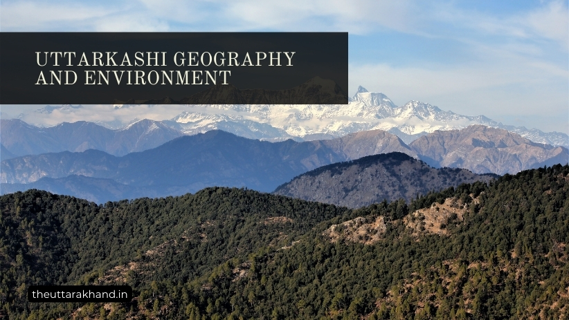
The district has extreme geographic diversity, with snow-capped mountain peaks, glaciers, rivers, forests, agricultural lands, and human settlements. The elevation rises from about 1,100 m in the southern part to over 7,000 m in the northern mountain ranges bordering China.
Uttarkashi Geography and Environment : Description of terrain and climatic conditions
Terrain
The terrain of Uttarkashi district consists of high mountain ranges interspersed with deep valleys and gorges. The northern part borders Tibet and contains peaks like Kamet, Mana and Khatling glaciers. The Bhagirathi and Yamuna rivers originate from these glaciers. The middle part of the district lies in the Lesser Himalaya, with heights ranging from 1,500 m to 3,500 m. The southern part borders Tehri Garhwal and contains valleys and low hills.
Some major landforms in Uttarkashi:
- Mountains and Peaks: Kamet (7,756 m), Mana Pass (5,545 m), Bandarpunch (6,316 m), Chaukhamba (7,138 m)
- Glaciers: Gangotri, Bhagirathi Kharak, Satopanth, Khatling
- Passes: Mana Pass, Niti Pass
- Valleys: Bhagirathi, Yamuna, Asiganga, Bhilangana
- Waterfalls: Vasukital, Nachiketa Tal
Climate
The climate of Uttarkashi varies considerably with altitude. While the northern snow-clad mountain ranges have an alpine climate, the temperate central region has relatively moderate temperatures. The southern valleys have sub-tropical climate.
Summer – The summer months of April to June are mild to moderately hot, with temperatures ranging from 25°C in the valleys to about 15°C in higher reaches.
Monsoon – The region receives moderate to heavy rainfall during the monsoon months of July-September. The annual rainfall is about 1600 mm on an average.
Winter – The winter months of December-February are cold, with temperatures dropping below freezing point in alpine region. Snowfall occurs at altitudes above 2500 m.
Spring – The spring months of March-May have a pleasant climate. Temperatures start rising towards summer.
Flora and fauna in the region
Uttarkashi district has a rich diversity of flora and fauna due to variation in altitudes and terrain. The forests exhibit multiple vegetation types. Over 1200 plant species have been recorded in the district. The key vegetation zones are:
Alpine Zone (above 3500m) – Sparse vegetation with mosses, lichens and herbs like saxifrages, sedges, primroses, gentians. Trees are almost absent. Animals like Himalayan Tahr, snow leopard, blue sheep inhabit this zone.
Sub-Alpine Zone (2300-3500m) – Coniferous trees like silver fir, spruce, pine, birch. Shrubs like rhododendron and juniper grow as understory. Musk deer, Himalayan black bear, monal pheasant are some fauna.
Temperate Zone (1500-2300m) – Oak, pine, deodar, fir forests with maple, chestnut, walnut. Leopard, barking deer, kalij pheasant, serow are some animals found here.
Sub-Tropical Zone (900-1500m) – Sal, pine, oak forests along with bamboo thickets. Elephant, sambar deer, sloth bear inhabit these forests.
The key wildlife sanctuaries in the region are Gangotri National Park and Govind Wildlife Sanctuary, protecting endangered animals like snow leopard and musk deer. Some 300 bird species inhabit the district.
The significance of the forest cover
The forests of Uttarkashi play a vital environmental role in terms of:
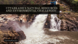
1. Preventing Soil Erosion – The dense forest cover with deep roots binds the soil, prevents landslides and regulates water flows in the fragile Himalayan ecosystem. Deforestation increases disasters like flash floods and landslides.
2. Carbon Sequestration – The forests absorb and store large volumes of carbon dioxide, offsetting greenhouse emissions and mitigating climate change impacts.
3. Regulating Water Flows – The forests recharge groundwater, release water gradually, filling rivers and streams. This regulates year-round water availability.
4. Supporting Biodiversity – The varied forests provide habitat for diverse flora and fauna. Many endangered animals like snow leopard depend on these forests for survival.
However, the forests are facing threats from developmental activities, overgrazing, forest fires etc. Concerted efforts are needed to conserve these vital Himalayan forests through community participation and eco-tourism promotion. The Uttarakhand government has launched reforestation programs by involving local Van Panchayats. But more needs to be done for the long term preservation of these forests.
Conclusion of Uttarkashi Geography and Environment
Uttarkashi Geography and Environment : Uttarkashi district has unparalleled geographic diversity from icy peaks to sub-tropical valleys. Its climate varies from freezing alpine to moderately hot sub-tropical. The forests exhibit multiple vegetation types that sustain rich biodiversity. These forests play a huge environmental role and need to be conserved through sustainable programs. Community stewardship of forests is essential for balancing development and conservation needs in this fragile Himalayan ecosystem.