Bageshwar – Sub-divisions and Administrative Structure
Bageshwar - Sub-divisions and Administrative Structures
Bageshwar – Sub-divisions and Administrative Structure
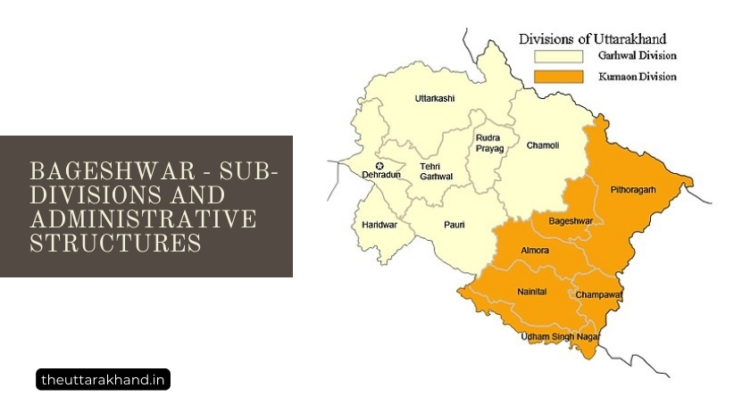
Bageshwar – Sub-divisions and Administrative Structure : Bageshwar district located in the Kumaon division of Uttarakhand state in India, was carved out from the Almora district in 1997. It is situated at the confluence of rivers Saryu, Gomti and Bhagirathi. Bageshwar has a rich history dating back to the 7th century rule of the Katyuri kings. Over the centuries, it has been part of various kingdoms before becoming part of British India after 1816.
The beautiful hill town of Bageshwar serves as the administrative headquarters of the district. The district is flanked by high mountains on all sides with the Bhileshwar and Nileshwar ranges to the east and west. Suraj Kund lies to the north while Agni Kund is situated in the south.
Sub-Divisions of Bageshwar
Bageshwar district comprises of 4 sub-divisions, 4 tehsils, 1 sub-tehsil and 3 community development blocks.
Sub-Divisions
The 4 sub-divisions of Bageshwar district are:
- Kanda: This sub-division is home to the scenic hill station of Kanda located at an altitude of 1500-1900 m above sea level. Surrounded by forests and hills, it offers stunning Himalayan views.
- Bageshwar: This is the main sub-division covering the district headquarters of Bageshwar town.
- Garur: Garur sub-division includes popular tourist and pilgrimage sites like the Pindari, Sunderdhunga and Kaphni glaciers.
- Kapkot: Kapkot sub-division houses the historic Baijnath temple, dedicated to Lord Shiva.
Tehsils
The 4 tehsils making up Bageshwar district are:
1. Bageshwar
As the main tehsil, Bageshwar covers the district headquarters. Important temples located here include the Bagnath Temple, Chandika Temple and Sriharu Temple.
2. Garur
The scenic Garur tehsil is home to the Panchachuli glaciers, Nanda Devi national park and Pindari glacier. It offers spectacular mountain views and abundant trekking opportunities.
3. Kapkot
Historic sites in Kapkot tehsil include the Baijnath temple complex and the ruins of the Katyuri kings. It also has hill stations like Kausani and scenic valleys.
4. Kanda
The Kanda tehsil comprises the beautiful hill station of Kanda along with several Himalayan peaks like Panwali Dwar, Nanda Ghunti and Trishul.
Sub-Tehsil
Bageshwar district has 1 sub-tehsil:
Shama: This sub-tehsil located close to the Pindari glacier is a popular trekking base. The area is also known for its unique culture and traditions.
Community Development Blocks
For local area development and administration, Bageshwar district is divided into 3 community development blocks:
1. Bageshwar
Covering the main town and surroundings, this block has several temples, the confluence of rivers at Bageshwar, and hill stations like Kanda.
2. Garur
The Garur block comprises spectacular mountain terrain including the Pindari, Sunderdhunga and Kaphni glaciers which attract trekkers.
3. Kapkot
This block is home to the historically significant Baijnath temple and also offers great scenic beauty with places like Kausani.
Conclusion to Bageshwar – Sub-divisions and Administrative Structure
Bageshwar – Sub-divisions and Administrative Structure : Bageshwar district with its 4 sub-divisions, 4 tehsils, 1 sub-tehsil and 3 community development blocks offers incredible natural beauty along with historic temples and monuments. Its hills, rivers and glaciers provide abundant opportunities for adventure sports like skiing, trekking and mountaineering. The unique culture, art forms and cuisine of the region also attract tourists. Thus, Bageshwar is gradually emerging as an important tourist destination in Uttarakhand.