Chamoli Geography

Chamoli Geography
Chamoli Geography
Description and Location
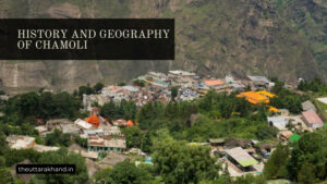
Chamoli Geography : Chamoli is one of the hill districts of Uttarakhand state in India. It occupies the north-eastern corner of the Garhwal region and lies in the central or mid-Himalayas.
Location
Chamoli district is bounded by the following regions:
- Uttarkashi district in the northwest
- Pithoragarh district in the southwest
- Almora district in the southeast
- Rudraprayag district in the south
- Tehri Garhwal district in the west
Chamoli district lies between latitude 29°45’N to 31°02’N and longitude 78°49’E to 80°06’E. The altitudinal variation in the district is from 880 m to 8,000 m above mean sea level.
Area
The total geographical area of Chamoli district is around 7,520 sq km. According to the Census 2011, it is the second largest district of Uttarakhand after Uttarkashi district.
Neighbouring Regions
Chamoli shares its borders with the following districts:
North: Lahaul & Spiti district of Himachal Pradesh
North-West: Uttarkashi district of Uttarakhand
West: Tehri Garhwal district of Uttarakhand
South-West: Pauri Garhwal and Rudraprayag districts of Uttarakhand
South: Almora district of Uttarakhand
South-East: Pithoragarh district of Uttarakhand
East: China (Tibet)
Physiography
Physiographically, the district can be divided into two distinct regions:
1. Greater Himalayan Range
The northern part of the district lies in the Greater Himalayan Range. This region consists of high rise mountain peaks, alpine meadows and glaciers. Some of the important mountain ranges and peaks found here are:
Nanda Devi Range: The Nanda Devi peak (7,817 m) lies on the northern edge of the ring of peaks encircling the Nanda Devi sanctuary. Other prominent peaks in this range include Dunagiri (7,066 m), Changabang (6,864 m), Kalanka (6,931 m) etc.
Kamet Range: Also called the Raishi Gang range, it has Kamet peak (7,756 m) as its highest point. Abi Gamin peak (7,355 m) lies in the eastern part of this range.
Mukut Parbat Range: The Mukut Parbat peak (7,242 m) is the highest point of this range located south of the Kamet range.
Trisul Group of Peaks: The Trisul group comprises of three main peaks – Trisul (7,120 m), Nanda Ghunti (6,309 m) and Maiktoli (6,803 m). Several glaciers descend from this group.
Panchchuli Group of Peaks: Panchchuli I (6,904 m) is the highest peak of this group located at the eastern end of the Johar valley.
Nanda Kot: Nanda Kot (6,861 m) peak stands majestically at the rim of the Nanda Devi sanctuary ring.
Several glaciers like Pindari, Milam, Namik and Poting glaciers originate from these high mountain peaks. The snow melt from these glaciers form the headwaters of important rivers like Gori Ganga, Dhauli Ganga, Nandakini etc.
2. Lesser Himalayan Range
The southern part of the district falls in the Lesser Himalayan Range. It consists primarily of steep hills, dissected ridges and intermontane valleys. Some of the notable ranges found here are:
Narayan Parbat Range
Pindar Range
Kaligarh Range
Gangotri Range
Bhagirathi Range
Jalandhari Ganga Range
This region has wider valleys and lower hill ranges as compared to the northern mountain ranges. Several rivers like Alaknanda, Mandakini, Pindar etc. flow through these valleys.
Different Areas within the District
Based on geographical features, Chamoli district can be divided into the following areas:
1. Upper Alaknanda Valley
The Upper Alaknanda valley extends from the origin of Alaknanda river at Satopanth glacier (4,400m) up to Helang (58 km). It is made up of deep gorges formed by the turbulent Alaknanda river. The valley has steep mountain slopes covered with snow and glaciers.
Main Peaks: Satopanth (7,075m), Chaukhamba (7,138m), Neelkanth (6,597m) etc.
Main Glaciers: Satopanth, Bhagirath Kharak, Chaukhamba
Important Places: Badrinath, Mana, Pandukeshwar
2. Lower Alaknanda Valley
The Lower Alaknanda valley stretches from Helang village to Devprayag (154 km) where Alaknanda meets Bhagirathi river. The mountain slopes are relatively gentle here and the valley is wider allowing more settlement and cultivation.
Main Rivers: Alaknanda, Nandakini, Pindar, Mandakini
Important Places: Karnprayag, Gauchar, Ghat, Joshimath, Govindghat, Pandukeshwar
3. Dhauli Ganga Valley
The Dhauli Ganga river is formed by the confluence of river Nanda Ghunti in the eastern part of Nanda Devi sanctuary. It meets Alaknanda river at Vishnuprayag near Joshimath. The Dhauli Ganga valley lies to the east of Alaknanda valley.
Important Peaks: Panchachuli (6,904m), Rajrambha (6,537m)
Important Glaciers: South Almora, North Almora
Important Places: Pithoragarh, Dharchula
4. Eastern Valleys
The easternmost part of Chamoli district is made up of valleys of various tributaries of Kali and Sharda rivers. Some of the important valleys in this region are Darma, Byans and Tirthan. This area offers beautiful mountain and forest landscapes.
Important Places: Ghat, Dugtu
5. Southern Valleys
The valleys of Madhayamaheshwar river and its tributaries like Lasku Gad, Garud Ganga etc. are located in the southern part of the district. This relatively inaccessible area lies close to the border with Pauri Garhwal district.
Important Places: Madmaheshwar
Conclusion of Chamoli Geography
Chamoli Geography, Chamoli district has great geographical diversity across its different regions. The landscape varies from snow-capped mountain peaks in the north to forested valleys and hills in the south. Several important rivers originate from the glaciers and high altitude lakes of the district. The unique topography and biodiversity of Chamoli provides immense opportunities for tourism and adventure sports. Protection of the fragile Himalayan ecosystem is crucial for the future development of the region.