Geography and Climate of Rudraprayag District, Uttarakhand

Geography and Climate of Rudraprayag
Geography and Climate of Rudraprayag District
Geography and Climate of Rudraprayag District : Rudraprayag district is located in the Garhwal region of Uttarakhand state in India. With an area of 2439 sq km, it lies between latitude 30°-15′ N & 31°-15′ N and longitude 78°-49′ E & 80°-0’E. The district is bounded on the north by Uttarkashi district, on the east by Chamoli district, on the south by Pauri Garhwal district, on the southwest by Tehri Garhwal district, and on the northwest by Dehradun district.
Rudraprayag district has a highly varied topography, ranging from 300 meters to over 6000 meters above sea level. This extreme variation in altitudes leads to a diversity of climates within the district, from sub-tropical in the southern regions to alpine in the higher Himalayan peaks.
Geography and Climate of Rudraprayag District : Geography
Physiographic Divisions
Based on physiographic features, Rudraprayag district can be divided into following zones:
1. Shivalik Range
The southernmost part of the district lies in the Shivalik hills, the outermost and lowest range of the Himalayas. This area has altitudes ranging from 300-1100 meters. The slopes are steep and the Shivalik range gives way to the plains near Rishikesh. The Song river flows through this region.
2. Doon Valley
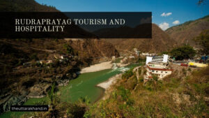
The Doon valley or dun valley is a wide valley between Shivalik hills and Lesser Himalayan ranges. It has an average elevation of 600 meters. The towns of Rudraprayag and Agustmuni lie in this valley. The Mandakini river flows through the dun valley in the district.
3. Lesser Himalayan Ranges
North of the Doon valley rise the imposing ridges of Lesser Himalayas, with altitudes between 1100-2200 meters. These ranges have steep rugged slopes and dense forests. The towns of Ukhimath and Chopta lie in these ranges locked between high mountain ridges on all sides.
4. High Himalayan Ranges
Further north lie the Higher Himalayan ranges with altitudes above 2200 meters. The famous Kedarnath peak lies in this region along with other high peaks like Kamet and Nanda Devi east. The region has snow-clad high peaks, glaciers and high-altitude Bugyals.
5. Valley Region
Between the Lesser Himalayan and High Himalayan ranges lies the valley region drained by Mandakini river and its tributaries. This region has an average elevation of 1500-2000 meters and the famous Panch Kedar temples lie in the Mandakini river valley.
Prominent Peaks
Some of the prominent peaks in Rudraprayag district are:
- Kedarnath – At 6940 meters, the Kedarnath peak is the most famous peak located near the Kedarnath shrine.
- Kamet – At 7756 meters, Kamet is the highest peak located entirely in the district and also in the Garhwal region.
- Chaukhamba – The Chaukhamba peak, at 7138 meters, is a four-peaked massif, with Badrinath peak being the highest.
- Nanda Devi East – At 7434 meters, this peak lies on the eastern border of the district along with Nanda Devi sanctuary.
- Kalanka – Kalanka peak at 6931 meters lies to the northwest of Kedarnath.
- Mandani – At 6193 meters, Mandani peak lies to the east of Kalanka peak.
- Mehragarh – At 5962 meters elevation, Mehragarh lies near Mandakini river valley.
Glaciers
Some important glaciers in the higher ranges of Rudraprayag district are:
- Satopanth Glacier – This large glacier lies below the Satopanth peak (7075m) and is source of Alaknanda river.
- Chorabari Glacier – Also called Gandhi Sarovar glacier, it is source of Mandakini river. Located near Kedarnath.
- Companion Glacier – Lies near Kamet peak and feeds Mandakini river.
- Mehragarh Glacier– Located below Mehragarh peak, also a tributary glacier of Alaknanda river.
Rivers and Lakes
The following are the main rivers flowing through the district:
1. Alaknanda River
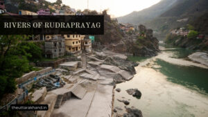
The Alaknanda is the main river flowing in the northern region. It originates from Satopanth glacier and flows in a southwest direction, cutting through the Higher Himalayan ranges. It meets the Mandakini river at Rudraprayag town.
2. Mandakini River
The Mandakini river is the chief river draining the central parts of the district. It originates from Chorabari glacier near Kedarnath and flows in a southern direction through the Mandakini valley. It meets Alaknanda river at Rudraprayag.
3. Song River
The Song river drains the southwestern region and forms the boundary between Rudraprayag and Tehri Garhwal districts. It joins the Yamuna river downstream.
Some famous high-altitude lakes in the district are:
- Deoria Tal – At an altitude of 2290 meters, Deoria Tal lies in chopta valley with beautiful views.
- Vasuki Tal – At 4150 meters elevation, this lake lies on the trek route to Kedarnath peak.
- Surya Kund – This scenic lake with floating ice lies at 4600 meters enroute to Satopanth peak.
Geography and Climate of Rudraprayag District : Climate
Factors Influencing Climate
The climate of Rudraprayag district is influenced by following geographical factors:
- Altitude – The elevation ranges from about 300 meters to over 7000 meters leading to climate varying from sub-tropical to permanent ice/snow.
- Latitude – The district lies between 30°-31° North latitudes. This mid-latitude location means it lies in the path of seasonal monsoon winds.
- Physiographic features – The high mountain ridges in the north bar the cold winds from central Asia. The Shivalik hills in the south block the hot Indian plains winds. This leads to overall pleasant climate.
- Upper air circulation – The westerly disturbances during winter and tropical easterly winds in summer influence the weather and precipitation patterns.
Climate Based on Altitude
The climate of Rudraprayag district can be classified into following altitudinal zones:
1. Sub-tropical zone – Up to 900 meters
This includes the Shivalik ranges and Doon valley region. Summers are hot with temperature reaching 38°C while winters are cool and pleasant with temperatures of 16-20°C.
2. Warm temperate zone – 900 to 1800 meters
Most of the Lesser Himalayan range falls under this zone. The region has temperate climate without extreme heat or cold. Summers (April-June) see temperatures of 25-30°C while winters (December-February) have chilly weather of 10-15°C.
3. Cool temperate zone – 1800 to 2400 meters
The Mandakini river valley and upper parts of Lesser Himalayas lie in this climate zone. Summers are mild with temperatures around 22°C while winters are very cold with freezing nights and temperatures dropping below zero. Snowfall may occur during peak winter.
4. Cold zone – 2400 to 4800 meters
This zone includes higher ranges like Kedarnath, Chaukhamba and Kalanka peaks. Summers are short and cool with average temperatures of 15°C and nights below 10°C even in peak summer. Winters are freezing cold with temperatures remaining below zero and heavy snowfall.
5. Glacier zone – Above 4800 meters
The region above 4800 meters has permanent snow and glaciers. Temperatures remain below freezing throughout the year. Peaks like Kamet and Nanda Devi East lie in this zone along with major glaciers.
Geography and Climate of Rudraprayag District
Geography and Climate of Rudraprayag District, Rudraprayag district has a highly complex geography comprising of several parallel ranges running in northwest to southeast direction. There is an extreme variation in altitudes, slopes and terrain which leads to diverse climatic conditions within the district, ranging from sub-tropical to permanent ice and snow. The rivers Alaknanda and Mandakini drain the region along with their numerous tributaries. The climate varies from hot sub-tropical in the Shivalik foothills to bitter cold alpine climate in higher peaks.
FAQs of Geography and Climate of Rudraprayag District
Q: What is the geography like in Rudraprayag district?
A: Rudraprayag has highly complex geography with elevation ranging from 300 to over 6000 meters leading to landscapes varying from Shivalik hills, Doon Valley, Lesser Himalayas, Higher Himalayas and glacial zones.
Q: What are the major rivers in Rudraprayag district?
A: The two main rivers flowing in the district are Alaknanda River and Mandakini River. Alaknanda originates from Satopanth glacier while Mandakini from Chorabari glacier near Kedarnath.
Q: How does the climate vary across Rudraprayag district?
A: There is extreme variation in climate based on altitude zones, ranging from sub-tropical in lower hills, warm temperate in middle ranges, cool temperate in higher valleys and freezing alpine in peaks above 4800m.
Q: What are the major climate influences in the region?
A: The extreme altitude variation, mid-latitude location, rain shadow effect and western disturbances primarily influence the climate. Monsoons bring heavy rains in summer.
Q: Which are the coldest places in Rudraprayag district?
A: The higher Himalayan peaks above 4800m like Kamet, Nanda Devi East have permanent snow and glaciers with bitter cold climate throughout the year.