History and Geography of Chamoli District

History and Geography of Chamoli District
History and Geography of Chamoli District
History and Geography of Chamoli District : Chamoli district is located in the state of Uttarakhand in northern India. It is part of the Garhwal region, known for its natural beauty and religious significance. Some key facts about Chamoli district:
- Area: Around 7,520 sq km
- Headquarters: Gopeshwar
- Main rivers: Alaknanda River and its tributaries such as Mandakini River
- Borders: Uttarkashi district, Pithoragarh district, Almora district, Rudraprayag district, and Tehri Garhwal district
- Key peaks: Nanda Devi (2nd highest in India), Trisul, Kamet, Dunagiri
- Main towns: Gopeshwar, Joshimath, Auli, Pandukeshwar
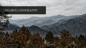
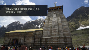
Chamoli lies in the central Himalayan region and is considered part of the sacred ‘Kedarnath’ area, known for important Hindu shrines and temples. The geography is dominated by high mountains, snow-covered peaks, glaciers, and deep river valleys.
Historically, Chamoli district has been inhabited since ancient times given its strategic location along important Hindu pilgrimage routes. It has been influenced and ruled by various dynasties and empires over the centuries.
Early History
The early history of Chamoli is not very well documented. However, there are references in ancient Hindu scriptures to the region of Garhwal, where Chamoli lies, being inhabited since early times.
Some key highlights of early history:
- Vedic period: The Garhwali language contains many words common to Sanskrit, indicating links to the Vedic culture. The region may have been where some Vedic saints and sages lived and composed parts of sacred Hindu texts.
- Epic period: There are legends that parts of the Mahabharata were composed by Vyasa Rishi in Vyas Gufa caves near Badrinath in present-day Chamoli district. The Pandavas may have spent time in the area during exile.
- Katyuri dynasty: The first documented rulers of Garhwal were the Katyuris, who had their capital at Joshimath in the 8th century CE. They promoted Shaivism sect of Hinduism in the region.
Medieval History
In the medieval period, Chamoli came under the influence of following key rulers and dynasties:
Gorkhas
In 1803, the Gorkha empire from Nepal invaded Garhwal and captured parts of Chamoli. The Gorkha Governor Amar Singh Thapa established his rule till 1815 when the British expelled them.
Panwar Dynasty
Local king Sudarshan Shah established the Panwar dynasty rule over Garhwal kingdom in the early 19th century. But he faced Gorkha invasions and later allied with the British to defeat them.
British Rule
In 1815, major parts of Chamoli came under British rule as the Garhwal kingdom was forced to sign a treaty ceding half the territory to the British. Eastern parts of Chamoli were designated as British Garhwal with headquarters at Tehri.
Modern History
In the 20th century, Chamoli district took its present-day form:
- It was initially under the combined Dehradun-Saharanpur district administered by the British.
- In 1960, Chamoli emerged as a separate district when the Uttar Pradesh government reorganized territories.
- In 1997, two subdivisions of Chamoli – Rudraprayag and Karnaprayag – were carved out to form Rudraprayag district.
Today Chamoli retains its strategic significance given its location near China border and continues to be a key pilgrimage site as well as base for mountaineering expeditions.
Origin of Chamoli District
The exact origins of human habitation in the Chamoli region are not clearly known. But there are references to early settlers, as well as links to important spiritual figures, based on legends and texts:
Early Inhabitants
The early inhabitants were likely tribal communities like Kiratas, Uttara Kurus, Khasas etc. These tribes found mention in ancient Hindu scriptures like the Mahabharata. They were attracted to the scenic landscape as well as its seclusion.
Rishis and Munis
The area that makes up Chamoli district has been mentioned in various Puranas and ancient texts as the abode of revered sages and seers. These include:
- Atri Rishi: Had his hermitage in a place called Anusuya, near present-day Chamoli town.
- Kashyap Rishi: Lived in the region of Gandhamadan Parvat close to Badrinath.
- Ved Vyas: Believed to have authored parts of the Mahabharata from Vyas Gufa caves near Badrinath.
The presence of such important and revered sages enhanced the sacredness of the region in popular imagination.
Lord Shiva
The Kedar Khand scripture mentions that Chamoli region was blessed and graced by Lord Shiva himself. There are several temples dedicated to Lord Shiva and related deities across Chamoli district even today.
Key Historical Events in Chamoli
Natural Disasters
The Chamoli region, falling in a sensitive ecological zone, has experienced several natural disasters over the centuries:
1803 Earthquake
A severe earthquake in 1803 badly affected Garhwal kingdom, including Chamoli district area. It resulted in thousands of deaths, economic losses, and administrative instability in the region.
1970 Avalanche
The Khatling Glacier collapse caused devastating floods and landslides across parts of Chamoli district near Nanda Devi mountain range leading to high casualties.
2021 Glacier Burst
In Feb 2021, a deadly flood caused by glacier fracture near Chamoli killed around 200 people and destroyed key infrastructure like dams and bridges. The ecological impact was immense.
Key Political Events
Some landmark political developments linked to Chamoli district area:
1803 Gorkha Invasion
Taking advantage of instability in Garhwal kingdom after the 1803 earthquake, Gorkha forces from Nepal invaded Chamoli and captured some areas.
1815 Anglo-Gorkha War
The British defeated Gorkhas in this war across Garhwal region. Subsequently, major parts of Chamoli were merged into British Garhwal territory as part of colonial administration.
Post Independence
After India’s independence in 1947, Chamoli became part of the new Uttar Pradesh state and later Uttarakhand state when it was created in 2000.
Influences of Different Rulers
Chamoli came under the rule and cultural influence of several dynasties who left an impact on local society and traditions:
Katyuris (8th Century CE)
- Originated in Joshimath area of Chamoli district
- First dynasty to rule unified Garhwal kingdom
- Promoted Shaivism sect of Hinduism
- Built iconic Adi Guru Shankaracharya’s Jyotirmath temple
Panwar Dynasty (19th Century)
- Traced origins to Chandpur Garhi fort of Chamoli
- Patronized Hindu pilgrimage sites like Badrinath
- Faced threats from Gorkhas and British
- Merged with British after Anglo-Gorkha war
British Colonial Era
- Focused on infrastructure like roads to aid pilgrimage tourism
- Promoted commercial enterprises like timber logging and mining
- Strategic cantonment town development in places like Joshimath and Auli
- Post independence, merged with Uttar Pradesh state of India
Conclusion to History and Geography of Chamoli District
History and Geography of Chamoli District, Chamoli district has a long history dating back to ancient eras. As part of Garhwal Himalayan kingdom, it has seen the influence of Katyuri rulers, Panwar dynasty as well as British colonial administrators. Its sacred landscape and location along key mountain passes has meant Chamoli has always enjoyed an exalted position in popular imagination. But it has also experienced turbulent political events as well as natural disasters due to its ecological fragility. Today it retains its distinctive culture and identity which has evolved over centuries of unique historical experiences.