Glaciation and Snow-Line in Uttarakhand
Glaciers and snowfields extending down from the high Himalayas have sculpted Uttarakhand’s dramatic landscape over millennia.
Glaciation and Snow-Line in Uttarakhand
Glaciation and Snow-Line in Uttarakhand
Glaciation and Snow-Line in Uttarakhand : Uttarakhand, located in the Indian Himalayas, is home to some of the most extensive and remarkable glaciers in the world. The high altitudes and climate of Uttarakhand provide the perfect setting for glaciers to form and persist. These rivers of ice have played a pivotal role in shaping the state’s landscape over millennia through processes of erosion, transportation and deposition.
In this article, we will explore the key aspects of glaciation and snow-line in Uttarakhand. We begin with an overview of what constitutes a glacier, how they are classified and the factors controlling their formation and movement. Next, we examine the snow-line and its significance in demarcating the lower reaches of glaciation. A highlight of this article is a detailed look at Uttarakhand’s diverse assemblage of glaciers including their locations, dimensions and distinctive characteristics. We also assess the impacts of climate change on Himalayan glaciers and the consequences for communities downstream. Lastly, an account is provided of glacial landforms and deposits that provide enduring evidence of past glaciations in Uttarakhand when ice cover was far more extensive.
What is a Glacier?
A glacier is a large accumulation of ice, snow, rock and sediment that originates on land and moves slowly downslope under its own weight. Glaciers are found on every continent and are enormously varied in size, shape and movement. They are essentially ‘rivers of ice’ that are nourished by the annual accumulation of snow which eventually gets transformed into solid ice due to pressure exerted by overlying layers. A glacier is always on the move as gravitational forces continually pull the accumulated ice masses downslope.
Classification of Glaciers
Glaciers are classified based on their morphology, thermal characteristics and velocity:
1. Morphology
- Valley glaciers: Occupy a valley; the most common type
- Mountain glaciers: Small glaciers confined to hollows and depressions
- Piedmont glaciers: Formed by valley glaciers spreading out on flat land
- Cirque glaciers: Occupy a bowl-shaped depression on a mountain
2. Thermal Characteristics
- Temperate glaciers: At melting point throughout; high water content
- Polar glaciers: Below freezing point throughout; little water content
3. Velocity
- Active glaciers: Flow at a rapid rate
- Stagnant glaciers: Flow extremely slowly due to minimal replenishment
Glacier Formation
Several factors influence glacier formation:
- Climate: Cool temperatures to allow accumulation and preservation of ice
- Precipitation: Adequate snowfall to build up the glacier mass
- Slope: Provides the gravitational force to set the ice in motion
- Shape and orientation: Affects solar radiation receipt and ablation
- Debris cover: Insulates glacier ice and regulates melting
The zone where accumulation of snow exceeds ablation (melting and evaporation) is called the accumulation zone. The opposite case where ablation outpaces accumulation is the ablation zone. The boundary between these two zones is termed the equilibrium line.
The Snow-Line
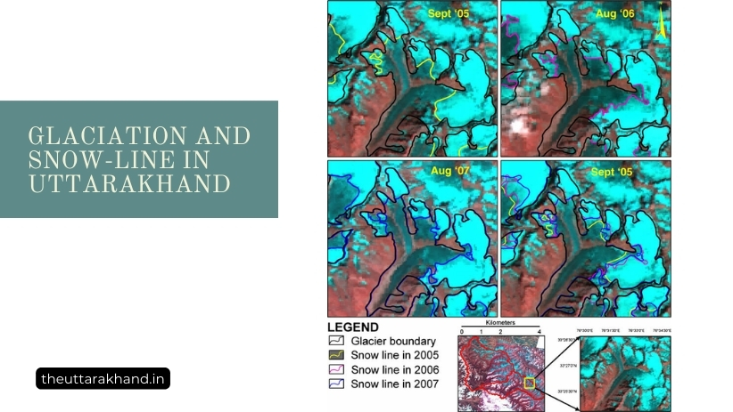
The climatic snow-line marks the lowest altitude at which snow persists year-round without completely melting. It delineates the lower limit of the perennial snow zone. In the Himalayas, the average altitude of the snow-line is around 5,200 m. However, it can vary by several hundred meters depending on factors like precipitation, temperature, slope and aspect.
The snow-line essentially separates the glacier accumulation zone from the ablation zone. Its precise boundary is difficult to demarcate as short-term climatic fluctuations allow snow cover to temporarily extend to lower elevations even during summer. Nevertheless, the snow-line altitude serves as a useful index of climatic conditions favoring glacier formation. Ascent of the snow-line to higher elevations indicates a warming climate unconducive to glaciation.
Glaciers of Uttarakhand
Uttarakhand contains one of the largest concentrations of glaciers outside the polar regions. Fed by some of the heaviest snowfall globally, glaciers occupy around 13% of Uttarakhand’s geographical area. There are estimated to be nearly 1,920 glaciers in Uttarakhand with a total glaciated area of around 3,015 sq km.
The following sections provide an overview of Uttarakhand’s extensive glaciers including their locations, dimensions and special attributes:
Major Glacier Groups
Uttarakhand’s glaciers occur as independent entities or coalesce into larger glacier complexes nourished by an intricate network of snow-fed tributaries. Among the largest glacier groups are:
1. Gangotri Glacier System
- 30 km long; 2 km wide
- Fed by Raktavaran, Swetavarnan and Chaturangi tributaries
- Snout forms the ice cave from which Bhagirathi River originates
2. Milam Glacier Group
- 62 km long; constitutes several tributary glaciers
- Feeds the Goriganga which joins the Kali River
- Accessible for trekking along with Nanda Devi National Park
3. Pindari Glacier Group
- Located in Kumaon Himalayas
- Over 32 km long with a width of 2 km
- Tributaries include Phurkia, Sunderdhunga & Maiktoli glaciers
4. Kafni Glacier
- 13 km long; situated close to the Pindari group
- Joins the Pindar River along with Pindari and Sundardhunga ice-flows
Longest Glaciers
The most extensive glaciers include:
| Glacier | Length (km) |
|---|---|
| Zemu | 26 |
| Kangriz | 24 |
| Siachen | 72 |
Lowest Glacier Termini
The lowest lying snouts where glaciers meet flat land are:
| Glacier | Terminus Elevation (m) |
|---|---|
| Milam | 3,660 |
| Gangotri | 3,140 |
| Pindari | 3,353 |
Glaciers Supporting Hydro-power
Major glacier systems feeding rivers dammed for electricity generation:
| Glacier Group | River | Dams |
|---|---|---|
| Gangotri | Bhagirathi | Tehri |
| Pindari | Pindar | Khati |
| Milam | Goriganga | Madkot |
Impacts of Climate Change
The Himalayan cryosphere (frozen parts of the landscape) is exceptionally sensitive to global climate change. Monitoring of Uttarakhand’s glaciers over recent decades has provided unequivocal evidence of accelerated glacier shrinkage.
Observed Impacts
- Retreated glacier fronts
- Reduced glacial mass, area and length
- Formation and expansion of moraine-dammed lakes
- Increased instability and risk of glacial lake outburst floods (GLOFs)
If current climatic trends persist, most small glaciers in Uttarakhand could disappear by end of the century. The larger glacier complexes are expected to lose up to 70% of their ice volume. Communities in the region are bound to suffer from long-term changes in water availability as glacier melt runoff initially surges then progressively declines over coming decades.
Glacial Landforms and Deposits
The forces of glaciation have sculpted Uttarakhand’s landscape over countless millennia. Glacial erosion by moving ice created characteristic landforms like U-shaped valleys, cirques, horns and arêtes. Deposition of eroded debris led to accumulations of till, moraines, drumlins and outwash plains.
These glacial features provide enduring field evidence of colder climatic periods in the past when glaciers in Uttarakhand were far more extensive in size and reached much lower elevations compared to present times.
Landforms
- U-shaped Valleys: Formed by glacial erosion; best exemplified by Upper Bhagirathi valley
- Cirques: Amphitheater-like hollows carved on mountain flanks; cradle for new glaciers
- Hanging Valleys: Tributary valleys meeting main glaciated valleys at different elevations
- Arêtes and Horns: Jagged narrow ridges and pyramidal peaks created by glacial erosion
Deposits
- Moraines: Mounds of glacial debris marking former glacier limits
- Drumlins: Elongate mounds oriented in direction of past ice flow
- Outwash Plains: Expansive plains of glacio-fluvial sediment near terminus
Conclusion to Glaciation and Snow-Line in Uttarakhand
Glaciation and Snow-Line in Uttarakhand : The foregoing account highlights the wealth of glaciers in Uttarakhand that make it an unparalleled region for glacier research and appreciation. These glistening rivers of ice are key lifelines sustaining Himalayan ecosystems and downstream communities through their year-round melt and runoff contributions to major river systems. However, recent decades have witnessed alarming retreat and downwasting of Uttarakhand’s glaciers driven by atmospheric warming and changes in precipitation patterns. Concerted climate change mitigation efforts are vital to slow the current meltdown and secure the future of these glacial reservoirs upon which so many livelihoods depend. At the same time, improved monitoring and risk assessment are needed in view of escalating threats from glacial lake outbursts and other glacier hazards exacerbated by climate change. Beyond the challenges they pose, Uttarakhand’s glaciers will continue to entrance and inspire with their ever-changing beauty. Their enduring presence is a testament to Nature’s magnificence in crafting these shimmering ice-scapes in the heart of the Himalayas.
FAQs:
What is the snowline elevation in Uttarakhand?
The snowline, or lowest limit of perpetual snow, is found at 5200m in the Uttarakhand Himalaya.
Where are glaciers located?
Glaciers are found above the snowline, so above 5200m in Uttarakhand.
What evidence shows Uttarakhand was once covered in ice?
Present landforms show evidence of past gigantic glaciers that sculpted the landscape over millennia.
How do glaciers influence local climate and vegetation?
Glaciers contribute to microclimates based on factors like temperature, precipitation. This affects vegetation.
How have glaciers shaped key geographical features?
Glaciers carved out U-shaped valleys, left moraines that dammed lakes, sharpened peaks through frost shattering.
What are some major glaciers in Uttarakhand?
Major glaciers include Gangotri, Milam, Pindari, Khatling, Ralam, Sunderdhunga, Satopanth, Dunagiri.