State Profile of Uttarakhand
State Profile of Uttarakhand
Introduction to State Profile of Uttarakhand
State Profile of Uttarakhand, Uttarakhand was formed on 9th November 2000 as the 27th State of India, when it was carved out of northern Uttar Pradesh. Located at the foothills of the Himalayan mountain ranges, it is largely a hilly State, having international boundaries with China (Tibet) in the north and Nepal in the east.
The state is rich in natural resources especially water and forests with many glaciers, rivers, dense forests and snow-clad mountain peaks. Char-dhams, the four most sacred and revered Hindu temples of Badrinath, Kedarnath, Gangotri and Yamunotri are nestled in the Himalayas.
Geography and Location
Location
Uttarakhand is situated in the northern part of the country between 28° 43′ N to 31° 27′ N latitudes and 77° 34′ E to 81° 02′ E longitudes. The Tropic of Cancer passes through this state.
Boundaries
- Uttar Pradesh in the South
- Himachal Pradesh in the North-West
- Tibet in the North
- Nepal in the East
Area
The total geographical area of Uttarakhand is 53,566 sq km. In terms of area, Uttarakhand ranks 16th in the country.
Physical Features
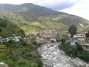
State Profile of Uttarakhand, Uttarakhand has variety of physical features, but is predominantly mountainous with the Himalayas in the north, Shivalik range in the south and middle Himalayan range in the middle.
There are a number of peaks, passes, valleys, glaciers, rivers etc which contribute to the diverse geography of the state.
Climate
The climate of Uttarakhand varies significantly with elevation. The plains experience sub-tropical climate where as middle Himalayan valleys have temperate climate. Alpine climate is prevalent in higher reaches of Himalayas.
Forests and Wildlife
Almost 65% of Uttarakhand’s geographical area is covered by forests. The state has a rich diversity of flora and fauna due to variety in habitats. Jim Corbett National Park, Rajaji National Park, Valley of Flowers National Park and Nanda Devi Biosphere Reserve are important protected areas.
Rivers and Lakes
The key rivers flowing through Uttarakhand are Ganga, Yamuna, Ramganga, Sharda etc. The state has several natural and artificial lakes like Tehri, Nainital, Bhimtal, Sattal etc.
Demographics
As per 2011 census, Uttarakhand has a population of 1.01 crore. The population density is 189 persons per sq km. The literacy rate is 79.63%.
Economy
The economy of Uttarakhand is largely dependent on agriculture and tourism. Other key sectors are manufacturing, energy, construction etc. The state GDP was estimated at ₹2.43 lakh crore in 2020-21. Per capita income in 2019-20 was ₹1.94 lakhs.
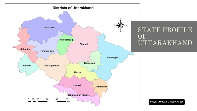
Districts
State Profile of Uttarakhand, There are 13 districts in Uttarakhand namely – Dehradun, Haridwar, Uttarkashi, Chamoli, Rudraprayag, Tehri Garhwal, Pauri Garhwal, Pithoragarh, Bageshwar, Almora, Champawat, Nainital and Udham Singh Nagar.
Culture
Uttarakhand has a distinct culture visible in its language, food, music, dance forms, architecture etc. The culture is deeply influenced by Hinduism.
Governance
As a state in the Indian federal structure, Uttarakhand has a Legislative Assembly, High Court and its own government policies and programs. Local governance is managed through urban and rural local bodies.
Key Issues
Some of the major issues and challenges facing Uttarakhand are underdevelopment, disasters, environmental degradation, outward migration etc. The state needs a sustainable development model suited to its unique geography.
Detailed Analysis on State Profile of Uttarakhand
Now let’s analyze the different aspects of Uttarakhand in detail:
Formation of Uttarakhand State
State Profile of Uttarakhand, Uttarakhand was carved out as the 27th state of India on 9th November 2000 after the Parliament of India passed the Uttar Pradesh Reorganisation Act 2000. It was formed by separating the hilly districts of Uttar Pradesh.
The demand for separate state for this region has history in the Chipko movement and Uttarakhand movement led by activists and local leaders. The movement gained momentum in 1990s.
The rationale for statehood included:
- Backwardness of the region despite its rich natural resources
- Difficult geographic terrain not suited to plains region
- Unique culture and practices of the hill people
- Better administration and development after smaller state formation
Geographical Profile
Uttarakhand is located in the northern part of the country making it a Himalayan state. Let’s look at the geography in detail:
Location and Extent
Latitudinal Extent: 28° 43′ N to 31° 27′ N
Longitudinal Extent: 77° 34′ E to 81° 02′ E
The Tropic of Cancer passes through this state.
The maximum length from east to west is about 500 km The maximum width from north to south is about 150 to 250 km
Boundaries
Uttarakhand touched international boundaries with China (Tibet) in the north and Nepal in the east.
The state boundaries are:
- Uttar Pradesh in the South
- Himachal Pradesh in the North-West
- Tibet in the North
- Nepal in the East
Area
The total geographical area of Uttarakhand is 53,566 sq km.
In terms of area, it ranks 16th amongst the 28 states of India.
Out of the total area of 53,566 sq km, more than half comprises of hills and mountains.
Physical Divisions
The state can be divided into following physical divisions:
- The Great Himalayan Range – This makes up the northern high mountainous region of the state. It contains country’s second highest peak Nanda Devi (7,817 m).
- Middle Himalayan Range – This runs parallel to Great Himalayan range at an average height of 6,000 feet. It has popular hill stations like Mussoorie, Almora, Ranikhet, Kausani etc.
- Shivalik Range – Also known as Outer Himalayas, it represents southern most division where most of the population is concentrated.
- Terai Region – This narrow belt lies south of Shivalik hills. It merges with Gangetic plains of Uttar Pradesh.
In terms of relief, the state has lofty mountains, deep gorges, valleys, lakes, glaciers etc along with plains and plateaus.
Important Mountain Peaks
Some of the important mountain peaks of Uttarakhand are:
- Nanda Devi (7,817 m) – 2nd highest in India
- Kamet (7,756 m)
- Trisul Group
- Bandarpunch (6,316 m)
- Kedarnath (6,940 m)
- Badrinath (7,138 m)
- Kanchenjunga (8,598 m)
- Panchchuli (6,904 m)
Passes
The main passes facilitating connectivity are:
- Niti Pass
- Lipulekh Pass
- Thaga La Pass
- Lamkhaga Pass
- Mana Pass
- Niti Pass
- Untadhura Pass
Climate and Rainfall
The climate of Uttarakhand varies significantly from place to place due to great variation in altitude.
There are mainly four climatic zones:
- Sub-Tropical Zone (upto 1200 m) – Found in Terai region with hot summer and cold winter
- Warm Temperate Zone (1200 m to 2400 m) – Pleasant climate during summer and severe cold in winter
- Cool Temperate Zone (2400 m to 3600 m) – Long and severe winter with snowfall and pleasant summer
- Alpine Zone (above 3600 m) – Snow cover for most part with extremely low temperatures
The annual rainfall also varies between 1,200 mm in sub-tropical zone to less than 250 mm in inner Himalayan valleys. Most of the rainfall is received during Monsoon season between June to September.
Rivers and Lakes
Uttarakhand has several perennial rivers that have their source in glaciers. The major rivers flowing through the state are:
- Ganga
- Yamuna
- Ramganga
- Kosi
- Sharda
- Kali
- Alaknanda
- Bhagirathi
- Mandakini
The key natural lakes are:
- Hemkund
- Roopkund
- Deoria Tal
- Nachiketa Tal
There are several artificial lakes created by dams such as:
- Tehri Dam Reservoir
- Nainital Lake
- Bhimtal Lake
- Naukuchiyatal Lake
- Sattal Lake
- Vishnuprayag Dam Reservoir
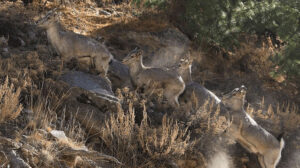
Forests and Wildlife
Uttarakhand has a recorded forest area of 34,650 sq km which is about 64.79% of the state’s geographical area.
In terms of forest cover as a percentage of total area, Uttarakhand ranks 2nd among Indian states.
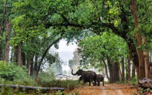
The state has a rich diversity of flora and fauna due to wide variety of habitats. There are four national parks and six wildlife sanctuaries.
Key National Parks and Wildlife Sanctuaries
- Jim Corbett National Park
- Rajaji National Park
- Valley of Flowers National Park
- Nanda Devi National Park
- Govind Pashu Vihar National Park
- Askot Musk Deer Sanctuary
The key wildlife found are tigers, Asiatic elephants, leopards, sloth bears, Himalayan black bears, antelopes, monals, musk deer, goral etc.
Agriculture and Horticulture
About 12.2% of the total land area in the state is under cultivation. Paddy, wheat and millets are the key crops grown. Uttarakhand is also known for horticulture production.
The major fruits under cultivation are apples, apricots, peaches, pears, plums, almonds and walnuts. Off-season vegetables and flowers are also grown in parts of the state.
Minerals and Industries
Uttarakhand has deposits of limestone, marble, rock phosphate, dolomite, magnesite, copper graphite etc. However, mining employs only about 1% of the workforce.
Industries contribute about 18% of the Gross State Domestic Product. The key industries are tourism, food processing, mineral based units, software, pharmaceuticals etc. However, majority are small scale industries.
Transport and Connectivity
Transport infrastructure is not very well developed given the hilly terrain. Total road length is about 70,000 km including national highways and state highways. Rail network is limited with total track length of 345 km. Jolly Grant Airport near Dehradun and Pantnagar Airport are two operational airports. Rishikesh and Chinyalisaur have domestic air strips.
Tourism
Tourism is a major contributor to the state’s economy. Key tourist destinations are the Char Dham sites (Badrinath, Kedarnath, Gangotri and Yamunotri), Haridwar, Rishikesh, Mussoorie, Nainital, Ranikhet, Pithoragarh, Valley of Flowers etc.
Adventure tourism opportunities exist for trekking, mountaineering, river rafting, skiing, paragliding etc. The state hosted about 37 million tourists in 2019 including significant number of foreign tourists.
Population
As per the 2011 census, the population of Uttarakhand is 1.01 crore. In terms of population, it ranks 19th amongst Indian states.
The population density is 189 persons per sq km against national average of 382 persons.
The literacy rate is high at 79.63% (88.33% for males and 70.01% for females) against national average of 74.04%.
The sex ratio is 963 females per 1000 males. Child sex ratio of Uttarakhand is 890.
Society and Culture
Uttarakhand has a distinct culture visible in its language, food habits, music, dance forms, architecture etc. The culture is deeply influenced by Hinduism.
About 83% of the people are Hindus. Muslims, Sikhs, Christians, Buddhists and Jains are the other key religious groups.
Hindi is the official language. Garhwali and Kumaoni are widely spoken regional languages.
Cuisine mainly comprises of lentils, vegetables and rice along with regional specialties. Arts and handicrafts are also an important cultural aspect.
Administrative Structure
Uttarakhand has 13 districts for administrative purposes namely –
Dehradun, Haridwar, Uttarkashi, Chamoli, Rudraprayag, Tehri Garhwal, Pauri Garhwal, Pithoragarh, Bageshwar, Almora, Champawat, Nainital and Udham Singh Nagar.
There are 95 tehsils, 78 blocks and 16,826 villages.
Dehradun is the state capital. Gairsain is the summer capital of Uttarakhand.
The high court is located at Nainital.
Political Structure
The state has a unicameral legislative assembly with 71 members. The state sends five members to Lok Sabha.
BJP is currently in power under Chief Minister Pushkar Singh Dhami.
Local Governance
There are 6 municipal corporations, 38 municipal councils (Nagar Palika), 70 municipal boards (Nagar Panchayat) and 7 cantonment boards for urban governance.
Rural governance is managed through Gram Panchayats (village councils). There are 12,150 gram sabhas and 7,665 gram panchayats.
Government Programs and Initiatives
The state government undertakes many development programs, policy initiatives and welfare schemes on education, health, employment, agriculture, infrastructure, tourism etc.
Some major programs are Char Dham road connectivity project, Atal Ayushman Uttarakhand health scheme, Mukhya Mantri Swarojgar Yojana, Deen Dayal Upadhyay home stay scheme etc.
State Budget and Taxation
In 2021-22, Uttarakhand presented a ₹ 57,400 crore budget with focus on health, education, infrastructure, tourism etc.
Tax revenue forms a major component. Other sources are central transfers, non-tax revenue, disinvestment proceeds etc.
GST compensation due to the state has also been a recent issue affecting state finances.
Per Capita Income
The per capita income of Uttarakhand at current prices was estimated at ₹1.94 lakhs in 2019-20.
This is higher than the national average of ₹1.12 lakhs.
The state ranks 9th in terms of per capita income among Indian states.
Economic Growth
Uttarakhand has exhibited high growth rates in the past decade. However, the growth rate has slowed down in recent years.
As per recent estimates, the Gross State Domestic Product (GSDP) contracted by 7.6% in 2020-21 due to the COVID-19 pandemic.
The GSDP was estimated at ₹ 2.43 lakh crore in 2020-21.
Human Development
The state ranks 19th according to NITI Aayog’s SDG India Index 2020-21 which evaluates progress on social, economic and environmental parameters.
The human development index value as per NFHS-4 survey was 0.57.
Key parameters like literacy, poverty reduction, child nutrition, health access require greater focus.
Employment Structure
The latest Periodic Labor Force Survey report shows that the worker population ratio in urban Uttarakhand is 32.1% while the ratio is 48.7% in rural areas.
About 58.8% workforce is engaged in agriculture and allied sector activities. Industry employs 14.4% while services account for remaining 26.8% as per 2017-18 estimates.
Migration
Migration especially from hill districts to plains is a persistent phenomenon. Lack of livelihood opportunities within the state leads to out migration.
As per Census 2011 data, about 1.6 million people born in Uttarakhand were settled outside the state due to economic compulsions. Addressing this requires urgent policy attention.
State Finances and Public Finance Management
The state government’s receipts consist of tax revenue, non-tax revenue, state’s share in central taxes and grants from the central government.
In 2019-20, state’s own tax revenue was ₹ 8,796 crore while non-tax revenue was ₹2,094 crore. Share in central taxes was ₹ 11,442 crore.
The fiscal deficit is estimated to be 4.5% of GSDP in 2021-22. The debt to GSDP ratio stands at 31.7% in 2021-22 BE.
Foreign Direct Investment
Cumulative FDI inflows in Uttarakhand from October 2019 to March 2021 was nearly US$ 217 million.
Computer software and hardware has attracted highest FDI equity inflow followed by services, trading, automobile, construction, tourism etc.
Forest Fires
Forest fires are a major issue for Uttarakhand especially in summer months. Pine forests and oak forests face increased vulnerability. Causes are both natural and anthropogenic. Steps taken for prevention and mitigation include early warning systems, controlled burning, fire lines etc. Community participation through van panchayats and JFMCs is also promoted.
Biomedical Waste Management
With increasing health infrastructure, proper disposal of biomedical waste has become important. There are efforts on way for streamlining collection and treatment systems. Rules for segregation, storage, transportation and treatment of various waste categories have been laid down.
Natural Disasters
The hilly terrain coupled with ecological fragility makes the state prone to natural disasters like landslides, flash floods, cloudbursts etc. Events like 2013 Kedarnath tragedy highlight the vulnerability. Early warning systems, zoning of risk areas, control on infrastructure development activities in hazard prone region, relief mechanisms etc. are being strengthened.
Van Panchayats
Van Panchayats are important grassroot level institutions managing community forests. There are over 7000 Van Panchayats in the state protecting valuable forests and ensuring livelihood for villagers. However, their functioning can be strengthened further through financial and institutional support.
Environmental Movements
Uttarakhand has a long history of environmental movements like Chipko movement which have highlighted ecological issues and livelihood concerns. These movements have shaped policies over forest conservation, benefits to hill communities etc. Their legacy continues to inspire conservation efforts.
State Biodiversity Board
Uttarakhand Biodiversity Board oversees implementation of provisions under Biological Diversity Act like documentation of biodiversity, granting approvals for access, benefit sharing arrangements etc. Biodiversity Management Committees also assist it at local level.
Budgetary Deficit
Managing deficit has been an issue. Expenditure liabilities are high coupled with limited avenues for revenue generation. Share of central taxes and grants is also important. Post GST implementation, state saw decline in tax revenues. Steps to expand sources of non-tax revenue and encourage economic activities are required.
Tourism Promotion
Tourism requires policies to reduce seasonality, improve connectivity, disaster management during char dham yatra, managing tourism’s environmental impact etc. Specific steps like separate tourism satellite accounting, expanding home stays through schemes, managing char dham through single body on TTD lines, encouraging activities like paragliding etc. can help.
Power Sector
The state has good potential for hydroelectricity generation at about 27,000 MW against which only 3618 MW has been tapped till date. Government is undertaking projects like Dehradun-Kuwari Pass-Yamuna Hydro Power Project to further harness this potential in an environmentally sustainable manner.
FAQs on State Profile of Uttarakhand:
What is covered in the state profile of Uttarakhand?
The state profile of Uttarakhand covers details on history, geography, climate, economy, districts, culture, festivals, transport, tourism and wildlife sanctuaries.
What is the capital of Uttarakhand?
The capital of Uttarakhand is Dehradun. Gairsain is the summer capital of the state.
What are the major rivers in Uttarakhand?
The major rivers flowing through Uttarakhand are Ganga, Yamuna, Ramganga, Sharda, Kali, Alaknanda, Bhagirathi and Mandakini.
What industries are present in Uttarakhand?
The key industries in Uttarakhand are tourism, food processing, mineral based units, pharmaceuticals, handlooms & handicrafts among others.
Which are the famous tourist places in Uttarakhand?
Some famous tourist places in Uttarakhand are Badrinath, Kedarnath, Haridwar, Rishikesh, Mussoorie, Nainital, Valley of Flowers, and Jim Corbett National Park.