Tehri Garhwal Geography Series on Location, Area, Boundaries
Tehri Garhwal Geography Series on Location, Area, Boundaries
Tehri Garhwal Geography : Location, Area and Boundaries
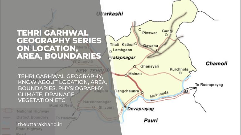
Tehri Garhwal Geography : Tehri Garhwal district is located in the Garhwal region of the northern Indian state of Uttarakhand. The district headquarters is at New Tehri town. With a total geographical area of 3,642 sq km, Tehri Garhwal district is bounded by several other districts of Uttarakhand.
Location
Tehri Garhwal district is situated between latitude 30°2’N and 31°2’N and longitude 77°49’E and 79°2’E. It lies in the Garhwal region of Uttarakhand state. The district headquarters at New Tehri town is located at an elevation of 1,550 metres above sea level.
Some major towns in Tehri Garhwal district include Ghansali, Narendranagar, Chamba, Mussoorie and Dhanolti. The district has tourist destinations like Surkanda Devi temple, Kempty Falls and Chandrabadni temple.
Area and Boundaries
Tehri Garhwal district has a total geographical area of 3,642 sq km. In terms of area, it is the third largest district in Uttarakhand state after Chamoli and Pithoragarh districts.
The boundaries of Tehri Garhwal district are:
North: Uttarkashi district
East: Rudraprayag district
South: Dehradun district
West: Garhwal region/Tibet
North-West: Chamoli district
On the northern side, Tehri Garhwal shares its boundary with Uttarkashi district. On the eastern side lies Rudraprayag district while Dehradun district forms the southern boundary. The western part of Tehri Garhwal comprises Tibet in China and the Garhwal region. Chamoli district lies to the north-west of Tehri Garhwal.
Geography Series
Physiography
Tehri Garhwal Geography : Tehri Garhwal district has a highly rugged topography due to its location amidst Himalayan ranges. There are high mountain peaks, deep valleys, snow-fed rivers and glaciers in the district. Based on physiographic features, Tehri Garhwal can be divided into three zones:
- Higher Himalayan Zone: Comprises very high mountain peaks covered with snow throughout the year. Glaciers originating from these peaks feed rivers in the region.
- Lesser Himalayan Zone: Consists of high hills, valleys and plateaus. Most of the inhabited region and agricultural lands lie in this zone.
- Sub-Himalayan Zone: Comprises foothills, terraces and valleys located close to the plains. Has a sub-tropical climate suitable for agriculture.
Drainage and Rivers
The following major rivers drain the region of Tehri Garhwal district:
- Bhagirathi River
- Bhilangna River
- Asi Ganga River
- Nandakini River
- Jahnavi River
The headwaters of the holy Ganges river, known as Bhagirathi, originate from the glaciers located in Tehri district. It merges with rivers like Jahnavi, Nandakini, Mandakini and Alaknanda before entering the plains near Rishikesh.
Climate and Rainfall
Due to high elevation mountain ranges, Tehri Garhwal has a sub-temperate to temperate type climate. Summers are mild while winters are cold. Rainfall occurs during southwest monsoon period.
The average annual rainfall is about 2,000 mm in Tehri Garhwal district. July and August months receive the maximum precipitation. Snowfall may occur at high altitude areas during winter months.
Soils
The soils found in Tehri Garhwal district can be classified into:
- Mountain Soils: Found on steep sloping terrain in higher altitudes. Prone to erosion.
- Forest Soils: Developed below forest vegetation. Rich in organic content. Good water retention capacity.
- Alluvial Soils: Found in river valleys and terraces. Suitable for agriculture due to fertile nature.
- Meadow Soils: Occur in bugyals or alpine grasslands. Rich in organic matter content.
Natural Vegetation
Tehri Garhwal district has a rich and diverse natural vegetation cover, which can be categorised into following types based on elevation:
- Tropical Deciduous Forests: Found in Sub-Himalayan zone up to 1,000 metres altitude. Sal, bamboo and shisham trees occur.
- Sub-Tropical Pine Forests: Occur between 1,000-2,000 metres elevation. Chir pine is the dominant species.
- Himalayan Temperate Forests: Mainly oak and deodar trees. Found between 2,000-3,000 metres altitude.
- Sub-Alpine Forests: Consist of fir, spruce, rhododendron, birch trees. Grow above 3,000 metres elevation.
- Alpine Grasslands: Treeless bugyals with rich grass and herb diversity. Occur from 3,500 metres and above.
Conclusion to Tehri Garhwal Geography
Tehri Garhwal Geography, Tehri Garhwal district located amidst Garhwal Himalayan ranges has a rugged mountainous terrain with snow-clad peaks, glaciers, deep valleys and gorges. Major rivers like Bhagirathi and Bhilangna drain the region. Varied climatic zones support diverse flora and fauna. The unique geography of the district makes it a popular tourist destination.