Uttarakhand Geography, Climate, and Natural Diversity
Uttarakhand Geography, Climate, and Natural Diversity
Uttarakhand Geography, Location and Boundaries Details
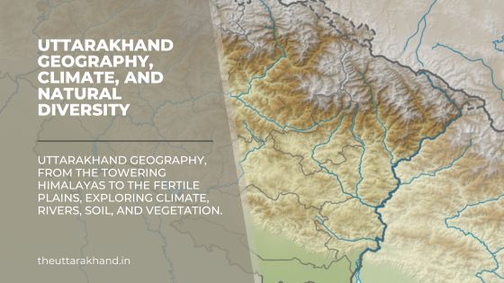
Uttarakhand Geography : Uttarakhand is a Himalayan state located in the northern part of India. With an area of 53,483 sq km, it borders Tibet in the north, Nepal in the east, Himachal Pradesh in the west and northwest and Uttar Pradesh in the south.
The state can be divided into two distinct physiographic regions – the Himalayas occupying the northern and eastern parts of the state and the plains region consisting of the Terai and Bhabar belts in the southwestern part. The Himalayan region can be further divided into three parallel zones – the Greater Himalayas, Lesser Himalayas and the Shivalik ranges from north to south.
Boundaries
- North – Tibet
- East – Nepal
- West – Himachal Pradesh
- South – Uttar Pradesh
Terrain and Physiography
The physiography of Uttarakhand can be divided into following physical divisions:
1. The Great Himalayan Range
The Great Himalayan range, also known as Himadri forms the northernmost rugged mountain zone in the state. It includes India’s second highest peak, Nanda Devi (7,817 m) along with other high peaks like Kamet (7,756 m), Bandarpunch (6,316 m) and Chaukhamba (7,138 m).
The Great Himalayan range has an average elevation between 6,000-7,000 m and width of around 50 km. It is composed of highly metamorphosed rocks and is traversed by swift flowing rivers cutting through deep gorges. Glaciers like Gangotri, Yamunotri and valley of flowers are located here.
2. The Lesser Himalayan Range
The Lesser Himalayan range or Himachal lies to the south of the Great Himalayas. It has an average elevation between 1,500-2,700 m and width of 75 km. It is composed of highly compressed and altered sedimentary rocks. The region is dissected by a series of ridges and valleys with the valleys often occupied by scenic lakes like Bhimtal, Naukuchiyatal and Nainital.
3. The Shivalik Ranges
The Shivalik ranges are located along the southern fringe of the Lesser Himalayas. They form the outermost range of the Himalayas in the state with average elevation below 1,500 m. The Shivaliks are composed of soft sediments like sandstone and clay. The northern slopes are steep while the southern slopes gently descend towards the plains.
4. The Tarai Plains
The Tarai plains form a narrow belt ranging between 10-30 km in width along the southern fringe of the Shivaliks. It lies at an elevation below 300 m and is composed of boulder formations called ‘bhabar’ in the north transitioning to finer alluvial soils in the south. The region has fertile soils but suffers from waterlogging.
Climate and Rainfall
Uttarakhand displays extremes of climate and rainfall patterns primarily based on altitude. While the northern mountainous region remains cold throughout the year, the southern Tarai plains record quite high temperatures. The state receives rainfall from both the southwest (summer) and northeast (winter) monsoons. Following are the major climatic zones from north to south:
1. Arctic Zone (above 4,500m)
This zone lies above the snowline and includes peaks and glaciers. Temperature remains below freezing throughout the year with permanent snow cover. Precipitation is in the form of snowfall.
2. Alpine Zone (3,000 – 4,500m)
The zone experiences cold climate all year round with temperatures averaging 0-10°C. Precipitation occurs as snowfall and rainfall averages 50-75 cm annually. The zone is marked by meadows or ‘bugyals’.
3. Cool Temperate Zone (1,800 – 3,000m)
This zone covering slopes and valleys experiences a pleasant climate during summers and cold winters. Temperature varies from 15-20°C in summers to -2 to 10°C in winters. Rainfall ranges from 100-250 cm per year. Coniferous vegetation dominates the landscape.
4. Warm Temperate Zone (900 – 1,800m)
The zone experiences a moderate climate with temperatures varying from 25-30°C in summers to 10-15°C in winters. Rainfall ranges between 100-200 cm per year. Broad-leaved temperate trees with species like oak, pine and deodar are found.
5. Sub-Tropical Zone (400 – 900m)
This zone located along the southern slopes of the Lesser Himalayas records rather high temperatures in summers that can go up to 40°C. Winters are cool with temperatures of 15-20°C. Rainfall is around 160-200 cm per year mostly occurring during the southwest monsoon season. The zone supports crops like wheat, rice and sugarcane.
6. Tropical Zone (below 400m)
The southernmost Tarai zone has a tropical climate with very hot summers and mild winters. Temperatures can range from 45-50°C in peak summers to around 15°C in winters. Rainfall is over 200 cm per year with humidity levels also being high. The landscape is marked by tall grasslands and forests.
Rivers and Drainage
Uttarakhand Geography : Uttarakhand’s rugged terrain is dissected by several swift flowing rivers and tributaries. The two most important river systems are:
1. Ganga River System
The Ganga river system is the major Himalayan drainage system in Uttarakhand. The two headstreams of Ganga – Bhagirathi and Alaknanda originate from the glaciers of Gangotri and Satopanth respectively in the Great Himalayas. They are fed by numerous tributaries as they flow south cutting through rugged mountainous terrain. Other major tributaries joining them include Mandakini, Pindar and Dhauliganga. At Devprayag, the merged river takes the name Ganga before entering the plains.
2. Yamuna River System
The Yamuna river originates from the Yamunotri glacier in Banderpunch range. It traverses parallel to the Ganga before entering the plains and joining it further downstream. Major tributaries of Yamuna in the state are Tons, Giri and Asan. Other smaller rivers flowing through the state include Ramganga, Kosi and Kali river.
Soil Types of Uttarakhand Geography
There are three broad soil categories found in Uttarakhand based primarily on the physiographic regions:
1. Mountain Soils
These soils occur in the Greater and Lesser Himalayas. They are generally immature, shallow and lack humus content. The texture varies from being coarse sandy loam to gravelly clayey loam. Alpine soils found above treeline are acidic in nature. Brown forest soils are more fertile and support temperate vegetation.
2. Sub-Montane Soils
These soils occur along the Bhabar and Tarai belt and Shivalik foothills. Alluvial soils deposited by rivers dominate with textures varying from sandy loam to silty clay loam. The Bhabar soils are excessively porous allowing easy percolation while Tarai soils have higher water retention and are more fertile.
3. Hill and Valley Soils
These soils are found along the various hill slopes, ridges and valleys in the Lesser Himalayan zone. They are generally immature, lack humus and are prone to erosion. The texture varies from stony loam to gravelly clay types. Soils found in valleys and terraces along rivers tend to be more fertile.
Natural Vegetation of Uttarakhand Geography
Uttarakhand Geography : Uttarakhand located in the temperate latitudes and having a varied terrain supports a diversity of forest types and vegetation zones. Following are the major natural vegetation zones from north to south:
1. Alpine Zone (above 3,600m)
Very cold conditions allow only seasonal grasses and shrubs to grow. Vegetation cover is very sparse and stunted. Common species include junipers, wild flowers and medicinal herbs. The zone is marked by high altitude bugyals or meadows.
2. Sub-Alpine Zone (3,000 – 3,600m)
Coniferous trees like silver fir, pine, deodar and spruce dominate the cool climate landscape. Deciduous trees like oak and rhododendron are also found. Grassland openings are common along steep slopes.
3. Montane Temperate Zone (1,500 – 3,000m)
Mixed vegetation comprising both coniferous and broad-leaved trees is found. Conifers include pine, deodar and spruce. Broad-leaved trees are oak and maple. The undergrowth consists of bushes and shrubs.
4. Sub-Tropical Zone (900 – 1,500m)
The zone supports moist deciduous forests. Sal is the most dominant species while others include haldu, bamboo, khair, sissoo etc. Tropical species start appearing as altitude decreases towards the south.
5. Tropical Zone (below 900m)
Hot and humid climate allows tropical vegetation comprising trees like sal, teak, shisham, jamun etc. The Tarai belt located in this zone supports very dense tall grasslands interspersed with sal forests and riverine vegetation.
Conclusion to Uttarakhand Geography
Uttarakhand Geography : Uttarakhand located in the central Himalayas displays great altitudinal variation in its terrain, climate, soil and natural vegetation. The northern mountainous region is cold, rugged and snowbound supporting only alpine vegetation while the southern Tarai plains record tropical climate supporting forests and grasslands. The state is also drained by major Himalayan rivers forming fertile valleys.