Drainage Systems in Uttarakhand

Drainage Systems in Uttarakhand
Drainage Systems in Uttarakhand
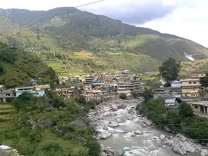
Uttarakhand, located in the northern part of India, is a hilly state with a complex drainage system. The state has several important rivers that originate from glaciers in the Himalayan mountain range. The major river systems that drain Uttarakhand are the Ganga, Yamuna, and their tributaries.
The drainage pattern in Uttarakhand is largely controlled by its rugged topography. The rivers in Uttarakhand are mostly rain-fed and snow-fed. The state receives heavy rainfall during the monsoon season, from June to September, which contributes significantly to the river discharges. Additionally, melting snow from glaciers is an important contributor to the rivers of Uttarakhand.
Major Drainage Systems
The three major drainage systems in Uttarakhand are:
- The Ganga Basin: The headwaters of the Ganga river system originate from the Gangotri glacier. The Bhagirathi and Alaknanda rivers, which meet at Devprayag to form the Ganga, drain a major portion of the state.
- The Yamuna Basin: The Yamuna river originates from the Yamunotri glacier. It drains the western parts of Uttarakhand.
- Sharda River Basin: The Sharda river originates from the Pithoragarh district and drains parts of eastern Uttarakhand before entering Nepal.
The Ganga Drainage System
The Ganga is the most important river system in Uttarakhand. The two main tributaries that form the Ganga – the Bhagirathi and Alaknanda, originate from glaciers at an elevation of around 4000-7000 meters.
The Bhagirathi
The headwaters of the Bhagirathi emerge from the snout of Gangotri glacier, one of the largest glaciers in the Himalayas. The Bhilangna river, emerging from the eastern slopes, is an important tributary of the Bhagirathi. As the Bhagirathi descends from its high-altitude origins, it carves out a deep gorge cutting through the Lesser Himalayan ranges. Several tributaries join the Bhagirathi in its lower course.
The Alaknanda
The Alaknanda originates from Satopanth and Bhagirath Kharak glaciers located at an elevation of around 4000-5000 meters. The Alaknanda basin drains parts of Chamoli, Rudraprayag and Pauri Garhwal districts. The major tributaries of Alaknanda are the Dhauli Ganga, Nandakini, Pindar and Mandakini rivers which originate from the high altitude regions and glaciers of the Great Himalayan range.
Confluence of Bhagirathi and Alaknanda
The Bhagirathi and Alaknanda rivers meet at Devprayag at an elevation of around 830 meters to form the Ganga river. Below the confluence, the Ganga flows through the plains of Uttarakhand carving a wide valley. The major tributaries joining the Ganga in the plains are the Ramganga, Kosi and Kali rivers. The Ganga river exits Uttarakhand near Kichha and enters the state of Uttar Pradesh.
Some key points regarding the Ganga drainage system:
- It drains around 62% of the geographical area of Uttarakhand
- The Ganga basin covers 11 districts out of the 13 districts in Uttarakhand
- The Ganga river system is the lifeline of Uttarakhand supporting agriculture, hydropower generation, drinking water supply and more
- The glacial meltwater contributes significantly to the Ganga river discharges, especially during the summer months
The Yamuna Drainage System
The Yamuna is the second largest river system in Uttarakhand after the Ganga. The Yamuna originates from the Yamunotri glacier located in Uttarkashi district at an elevation of around 6,387 meters.
The Yamuna carved a deep gorge in the Lesser Himalayan ranges on its descent from the high altitude areas near Yamunotri. The major tributaries of the Yamuna in Uttarakhand are the Tons, Giri and Asan rivers. These tributaries originate from the Great Himalayan range located north of the Lesser Himalayas.
The Yamuna basin covers around 12.2% of the total area of Uttarakhand, spread across the districts of Uttarkashi, Dehradun and Tehri Garhwal. The Yamuna river exits Uttarakhand near Dak Pathar and enters Haryana state.
Some key aspects of the Yamuna drainage system:
- The discharge in Yamuna river fluctuates significantly across seasons based on rainfall and snowmelt patterns
- Several hydropower projects have been constructed on the Yamuna and its tributaries
- The Yamuna river supports irrigation and drinking water supply systems in parts of Dehradun, Tehri Garhwal and Uttarkashi districts
Sharda River Drainage System
The Sharda river, also known as the Mahakali river, originates in the Pithoragarh district of Uttarakhand near the Nepal border. The river flows through the easternmost parts of Uttarakhand in Pithoragarh district before entering Nepal.
The major tributaries of Sharda river in Uttarakhand are Dhauli Ganga, Gori Ganga and Kali river. These rivers originate from the high altitude areas and glaciers of the Great Himalayan range located north of the Sharda river basin.
The Sharda river drains around 5.4% of the total geographical area of Uttarakhand, covering parts of Pithoragarh district. After entering Nepal, the Sharda river is an important tributary of the Ghaghara river system.
Some salient features of the Sharda river basin:
- Supports irrigation systems in the lower valleys and plains of Pithoragarh district
- Prone to frequent flooding during monsoon season due to heavy rains
- Hydropower projects proposed on Sharda river and its tributaries
Other Drainage Systems
In addition to the major river basins described above, Uttarakhand has several smaller rivers and streams that drain localized catchments and meet the larger rivers.
Some of the other drainage systems in Uttarakhand are:
Ramganga River Basin
The Ramganga river originates near Gairsain in Chamoli district. It drains parts of Pauri, Almora and Nainital districts before meeting the Ganga river near Kalagarh.
Eastern Nayar Basin
The eastern Nayar river originates near Milam glacier and drains high altitude areas in Pithoragarh district.
Western Nayar Basin
The western Nayar originates from the Pindari glacier and drains parts of Bageshwar and Pithoragarh districts.
Balia Nadi Basin
The Balia Nadi originates near China border and drains eastern catchment areas in Pithoragarh district.
Drainage Patterns
The drainage pattern in a region depends on various geographical factors such as topography, slope, underlying rock structures and geological history.
Based on the configuration of streams, following drainage patterns can be identified in Uttarakhand:
Dendritic Drainage Pattern
In this pattern, the tributary streams join the main river stems at acute angles, resembling the branches of a tree. This pattern develops over homogeneous rocks and gentle sloping terrain.
Dendritic pattern can be observed in parts of Bhagirathi and Alaknanda river basins.
Trellis Drainage Pattern
In this pattern, the tributary streams meet the main rivers at right angles. This develops when rivers flow over folded and faulted rock structures.
Parts of Yamuna and Sharda river basins exhibit a trellis drainage pattern.
Radial Drainage Pattern
In the radial pattern, streams originate from a central elevated point and flow outwards in all directions. This type of pattern develops over dome-like structures and igneous rocks.
The headwater regions of Bhagirathi and Alaknanda rivers near Gangotri and Badrinath show a crude radial pattern.
Rectangular Drainage Pattern
This pattern develops over rocks with joints and fractures oriented at right angles. The streams follow these lines of weakness, forming an approximate rectangular geometry.
Rectangular drainage patterns occur in localized areas of Uttarakhand.
Factors Influencing Drainage Systems
The drainage systems in Uttarakhand have developed under the influence of several geographical and geological factors.
Relief and Slope
The youthful, rugged Himalayan landscape with high relief and steep slopes is the most important factor controlling the drainage. The swift flowing rivers have carved deep gorges while descending rapidly from high altitudes.
Rainfall Distribution
The rivers in Uttarakhand are heavily dependent on rainfall for their discharges. The spatial and temporal variation in rainfall governs the river flows across different seasons.
Snow Cover and Glaciers
The perennial snow cover and glaciers maintain river flows even during the dry months. Melting snow and ice is critical for sustaining base flows, especially in headwater regions.
Geology and Rock Structures
The underlying geological formations and structural features like folds, faults and fractures have influenced the orientation of rivers over long time periods.
Vegetation
Thick forest cover in parts of Uttarakhand helps in reducing surface runoff and soil erosion, thereby minimizing sediment load of rivers.
Anthropogenic Factors
Increasing human interventions in the form infrastructure construction, deforestation, mining etc. have impacted natural drainage patterns at local scales.
Role of Drainage Systems in Uttarakhand
The rivers and drainage systems of Uttarakhand play an indispensable role in supporting natural ecosystems and human society.
Support Biodiversity
The rivers and tributaries host rich aquatic biodiversity including fish, insects, algae and aquatic plants. Rivers maintain connectivity between forest ecosystems.
Agriculture and Irrigation
The rivers and streams are tapped extensively to provide irrigation water for agriculture in valleys and plains. Groundwater recharge from rivers supports well irrigation.
Hydropower Generation
Hydropower projects located on rivers and tributaries generate electricity for Uttarakhand and other states.
Drinking Water Supply
Major urban centers and rural areas depend on river water for drinking water supply after treatment. Rivers recharge groundwater aquifers used for water supply.
Inland Water Transport
Some of the larger rivers have historically provided connectivity and enabled inland water transport within Uttarakhand.
Recreation and Tourism
Rivers form an integral part of tourism landscape. Activities like rafting, angling and nature trails attract tourists. Several Hindu shrines and pilgrimage sites are situated along river banks.
Industrial Use
Water from rivers is used in various industries including agriculture and food processing, pulp and paper, textiles, pharmaceuticals, etc. located close to rivers.
Challenges Related to Drainage Systems
The increasing anthropogenic pressures and extreme climatic events pose several challenges to the sustainability of Uttarakhand’s drainage systems:
Deforestation and Soil Erosion
Deforestation in catchments has increased surface runoff and soil erosion resulting in heavy sediment loads in rivers, especially during monsoon season.
Climate Change Impacts
Climate change is projected to increase variability in weather patterns. Intense or prolonged rainfall events can cause devastating floods while declining snow cover reduces lean season river flows.
Hydro Projects Impacts
The dams, tunnels and diversion structures of hydropower projects have disrupted natural river flows in several parts of Uttarakhand with impacts on downstream drainage patterns.
Pollution
Discharge of agricultural runoff, urban wastewater and industrial effluents degrades river water quality. Solid waste dumping near rivers and improper disposal of waste from religious tourism are also causing pollution.
Flood Risk
Increasing encroachments into floodplains has amplified the vulnerability to flooding events which are already exacerbated by factors like climate change, deforestation and unplanned development.
Water Scarcity
Over-extraction and inadequate rains can cause acute water scarcity during certain times, especially the pre-monsoon months from March to June.
Recommendations for Sustainable Management
A long-term vision and integrated approach is required to manage and conserve Uttarakhand’s drainage assets.
Watershed Management
Scientific watershed management practices involving soil and water conservation, reforestation, check dams etc. can reduce erosion and surface runoff while improving base flows.
Floodplain Zoning
Strict regulation of activities in floodplains and river buffers should be enforced to minimize flood risks.
Restoration of Rivers
Programs for ecological restoration of rivers by improving habitat, water quality and flow regimes will boost biodiversity and ecosystem health.
Water Conservation
Techniques like rainwater harvesting, efficient irrigation methods and wastewater recycling should be promoted across urban and rural areas to conserve water.
Sustainable Tourism
Regulations on waste disposal from hotels, ashrams and pilgrimage sites and limiting visitor numbers in ecologically sensitive areas around rivers can prevent pollution and resource overuse from tourism.
Community-based Management
Involvement of local communities through mechanisms like river basin organizations and water user associations for decentralized management of smaller streams and watersheds.
Conclusion to Drainage Systems in Uttarakhand
Uttarakhand’s myriad rivers, lakes and watersheds nurture life, provide ecosystem services and support economic development. The naturally endowed drainage assets directly sustain millions of lives. However, increasing anthropogenic pressures pose threats to the health and integrity of these systems. Dedicated efforts are needed to conserve drainage networks through sustainable practices while also improving resilience to future challenges. The policy, planning and management regimes must integrate latest scientific tools and community participation for an integrated river basin scale approach. The conservation and judicious management of Uttarakhand’s precious water resources will be vital for long term ecological and economic security.
FAQs about Drainage Systems in Uttarakhand:
What are the major rivers and drainage systems in Uttarakhand?
The Ganga, Yamuna and Sharda rivers along with their numerous tributaries constitute the major drainage systems in Uttarakhand. The Ganga basin drains over 60% of the state’s area.
What are the different drainage patterns observed in the state?
Dendritic, trellis, radial and rectangular drainage patterns can be identified across different regions based on controlling factors like topography, geology and slope.
How do the rivers support biodiversity?
The rivers and tributaries provide habitat for aquatic species and maintain connectivity between forest ecosystems in the Himalayan landscape.
What is the importance of glaciers and snow cover?
Glacial meltwater and seasonal snow maintain regular base flows and lean season discharges in the perennial Himalayan rivers.
What are the major challenges related to drainage networks?
Deforestation, soil erosion, climate change impacts, extensive hydro development, increasing pollution levels and escalating flood vulnerability are some key issues.